12
Jan
10 Minute Read
First of all, this post is part of a greater series of posts that I’ve written about that documents my trip to the area in the summer of 2022. If you’re looking for more on that trip and where else I went, definitely check out the post!
Since I had an “extra” day of riding in the Côte d’Azur in July of 2022, primarily due to a mix up on my end, I opted to do one of the climbs that I hadn’t initially thought I’d have time for. In this case, it was the Col d’Eze, a beautiful coastal road that takes you up and out of the city of Nice and into the medieval town of Éze.
Well, for one, it’s sheer beauty. It follows the Route de la Grande Corniche from Nice over to the Éze region, just between the old town of Éze itself and the Fort de la Revère above it. The Col d’Éze is regularly part of the Paris-Nice professional race, and many cycling battles have been fought over this climb.
Of particular noteworthiness is Sean Kelly, who won the Paris-Nice race a record 7 times in the row from 1982 until 1988!
It’s quite a unique climb on its own, as it’s a very quick ascent up and out of the hustle and bustle of Nice, much more quickly than you may think. And then you’re greeted by a beautiful area secluded from the afternoon sun, filled with palm trees and villas.
Cafe du Cycliste has a La Gazette entry for this climb, with some beautiful photography that really showcase how this climb has been used over the years for training and for racing.
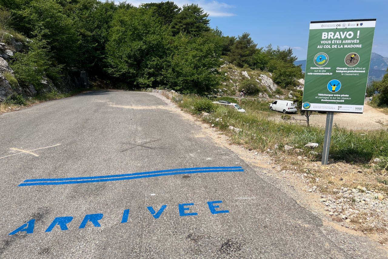
The Col d’Éze wasn’t the only thing on this route today. On this particular day, I mapped out a giant figure-8 loop, doing the Col de la Madone first, descending through Peille and Cap d'Ail, before heading back to Nice for a pit stop at Cafe du Cycliste.
After a delicious set of cool drinks and a few snacks, I was off on my way, saying goodbye to the lovely town of Nice. I had been lucky to traverse through a good portion of the eastern part of the city by this point, so it was off to experience a little bit more of French cycling history.

The Strava segment for the Col d’Éze says the full climb is 6 miles / 10km with 1682 feet / 512 meters, with an average gradient of 5.1%.
The number differs a bit, depending on your frame of reference, but according to the official sign I saw, the 10km climb is 490 meters to the top with an average gradient of 4.9%.

That doesn’t sound so bad, right? Well, it does get pitchy, with maximum gradients being around 10%, so don’t get too comfortable yet!
Based on my experience, there are three parts to this climb.
For whatever reason, I seem to remember this section most clearly. The road pitches up pretty quickly, and you’re basically sharing the road with a bunch of parked cars and condos. These condos have amazing views of the city of Nice, and the road was shockingly not all that particularly busy. I found myself wondering how much it would cost me to take a more permanent residency in the region.

It’s a bit exposed through this particular section, but mainly because the sun was lower in the sky in the afternoon and given the hill that I was climbing, there wasn’t a lot to shield me from the western sun. The road through here moves northward and upward, but largely in a pretty straight line. That is, until you start to make your way around Mont Boron.
Earlier during this ride, when I came to Nice initially along the coast via the towns of Cap d’Ail, Beaulieu-sur-Mer, and Villefrance-sur-Mer, I actually went around Mont Boron. There’s a military battery at the top of this hill that is quite popular with tourists, but lies further east than the one more commonly hiked by those same visitors, the Colline du Chateau or “ Castle Hill”.
This is where the road turns eastward and southward, as you ascend further, the road starts to ease up, and the shade of the trees in the afternoon sun definitely give you a sense of relief.
There were a few more signs showing you your progress up the climb (I love these), as well as some beautiful villas.

This one was quite uniquely colored, and is apparently a pavilion that’s part of the Observatory de la Côte d'Azur, which, as it turns out, has a dome that was built by Gustave Eiffel.
Eventually the trees start to open up again, and you can tell that you’re getting closer to the coast. This time, it’s through the Col des Quatre Chemins, which is a checkpoint along the time trial route and a slightly confusing intersection if you’re not already familiar with it.
Stay to the left at the fork and head upward. The road definitely pitches up here again, but you’re on your way to the next section of the climb.
As you get further out of the trees and pass more houses, you’ll notice the ever-present Mediterranean Sea again. It’s through here where you catch more of the views of what makes the French Riviera so appealing to those visiting. Unfettered views, incredibly blue seas, and beautiful roads with iconic rock walls.
From here, you can look back and down on the bay of Beaulieu. And you get to take in another view of those coastal cities east of Nice that each are just so quaint and delightfully French.

Bonus round! As the top of the climb approaches, the road actually eases up a bit and heads back away from the coast. Eventually you’ll realize that you’re actually going a bit downhill, so you’ll definitely catch some speed through here. Just make sure you don’t miss the official top of the climb on the left side of the road!


And there you have it! You’ll successfully conquered the Col d’Éze!
A lot of how I felt, and still feel, about this climb was a mixture of several things. At this point of my trip, I had been doing a lot of riding, so I was very ready to be done. But at the same time, I also realized, perhaps mostly along this stretch of road, just how much I would miss this place, this entire region.
I’m a fan of riding in a lot of different kinds of roads, usually switching between roads in dense cities like San Francisco and more quiet ones that let me “get away from it all”. This climb had a little bit of both. Climbing out of Nice, after having just gone through the city one more time, then gradually seeing shady trees, to seeing more epic views of the Côte d’Azur.
I remember seeing a family out in front of their house, elevated from the road, but enjoying the summer weather out front in their pool, which was situated away from the road. I remember thinking to myself about what it might have been like to live along this iconic road with such an incredible view, and just how unique that experience would be.
The climb itself was never anything too crazy, nothing like what I did later in the Italian Dolomites, but these are the exact climbs that I’ve found to be the most interesting to me. They let you push yourself (and your gearing) as hard or as easy as you want to, which often means you can push yourself harder than you otherwise would on even steeper climbs.
I can absolutely see myself coming back to experience this one again.
So, funny story, there wasn’t as much of a “descent” to this one as you may think. On this day, I opted to go exploring just a bit further, in an effort to avoid heading back down towards the coast to return to my starting point of Roquebrune-Cap-Martin.
This meant heading upward even more, past La Turbie once again, and up to the Monte Carlo Golf Club, which is up on Mont Agel.


This was both awesome and a bit rough, so let me elaborate.
Getting up to the golf club requires some more climbing, so if you choose to do this as well, be prepared for it! The road definitely gets a bit more quiet up there, but you somehow manage to feel even higher up than before. The top of the mountain, which you can see from below, has an active military base at the top, and is the tallest point in the Monaco region.


I actually wrote about this section of my adventure previously, as I was able to discover this route via several of my mapping tools that I use when it comes to planning my routes. And I’m glad I did, at least to this point. It was so cool to head up to what feels like a mountain in the sky that doesn’t really feel like that high up once you’re there.
And then you get to past the country club and see this sign and gate:


“No thoroughfare on pain of prosecution.” I’m sure that’s translated somewhat directly, but it’s also so wonderfully direct.
I definitely don’t recommend you go past this one! If you look at Strava's global heatmap, you’ll see that someone has, but I have no idea if that was a government employee who forgot to turn off his Strava or if it was someone pushing their luck a bit.
Either way, it was fun to be up there, but I was also ready to get back down off the mountain.
At least if you have a road bike! I didn’t want to double back down the way I came up, so I had previously mapped out what I thought was a road heading east, basically in a fairly straight path back to Roquebrune-Cap-Martin.
What I didn’t realize was that this road was dirt, gravelly, and sandy the whole way down.
I made it to a sign, I walked around it, and thought, “hey maybe it’s just a bit of dirt until the other side here”. Nope, it was dirt the whole way down the other side.

Beautiful views, though! It wasn’t that I was mad or angry, but more that it was the first time in my entire trip where things didn’t go so smoothly.

Luckily, after what felt like forever, I scooted and slided my way down to what was a parking lot at the base of the Col du Mont Gros trail. I love that the Google image for this showcases a full on mountain biker doing this trail.
In the name of my ride for this day, I included a mention of the Sunk Cost Fallacy. This is more of a financial term, but it’s basically a way to generally describe following through on a decision that may not be the best, but only because you’ve already put some much previous time, effort, or money into it so far that it feels stupid to not continue.
That’s kind of what happened here! Luckily nothing went wrong, and I’m glad I had this experience while being out there and on my own. I’m especially glad that it happened at the end of my trip rather than at the beginning, as something like this could have made me more hesitant to make other decisions that ended up being really good for me.

It was yet another insight that I had into how riding your bike is more mental than it is physical at times.
This was the fourth of four days of some seriously epic riding in the Côte d’Azur, and I really, really look back on all of this with fond memories. Col d’Éze was a fantastic way to finish it all out, as it’s about as quintessential French Riviera cycling as you can get! Definitely recommended from me, that’s for sure.
Bon Voyage!