09
Jan
9 Minute Read
First of all, this post is part of a greater series of posts that I’ve written about that documents my trip to the area in the summer of 2022. If you’re looking for more on that trip and where else I went, definitely check out the post!
Well, not initially for cycling! The Col de Turini is actually most known for being included in the Monte Carlo Rally, which was created in 1911 by Prince Albert of Monaco to promote new car technology and Monaco as a tourist destination.
Turns out that it was also featured in an episode of Top Gear, as the guys were out on a quest to find the “greatest driving road in the world”.
Perhaps it wasn’t the greatest driving road in the world, but it was a pretty incredible road for cycling!
If you’re staying in Nice or near the coast, you’ll find that this col is quite a journey to reach, as the most popular approach to the top appears to be from the town of Sospel. It’s a popular addition to an epic day out on the bike if you’re already tackling the great Col de Braus, as it’s nearby. This is actually a popular shop ride that Cafe du Cycliste has in their Nice Rider's Guide.
Just remember to fuel up in town, as the climb itself is quite long! “Long” being 24 kilometers long!
This was honestly my first impression when reaching the iconic gorge that this road is most known for. There are incredible striations of rock interspersed with trees and various kinds of brush and retaining calls on the side of what are basically cliffs.
There’s also a river at the base of it all, which is accessible at various points along the road, as I saw people heading down there to take a refreshing swim.
I can’t blame them, either. That particular day I was there, it was well into the mid 30’s celsius, and the only respite I had was the shadow that the impressive cliff faces provided me from the sun.
While the whole climb was just incredibly beautiful, climbing up the sinewing road through this first initial gorge was the highlight of the route. I definitely stopped too many times to take pictures along what was a relatively quiet road.
When I opted to tackle this climb, I combined it with the Col de Braus as was suggested by the Nice Rider’s Guide supplied by Cafe du Cycliste. This was the second day of my trip out there, so at least I was fresh enough to consider this route, which was quite epic in length and elevation.
Overall, that day took me 82 miles / 132 km and over 10800 ft / 3300 meters of ascent!
Before the “official” climb, meandering out of the town of Sospel was something other worldly in and of itself. Make sure to enjoy this portion of the ride, too! The road was quiet, and it followed through some countryside homes and farms, interspersed with trees that literally enveloped the road.

According to the Strava segment, coming up from Sospel is a long 15 miles / 24 km, with a total elevation gain of 3970 ft / 1210 meters!
In my experience with this climb, I remember it most distinctly in three separate portions.
After almost forgetting where I was in those beautiful trees, I suddenly noticed the mountain getting closer. The road opened up just a bit and then suddenly I was transported to the entrance of the rock-filled gorge.


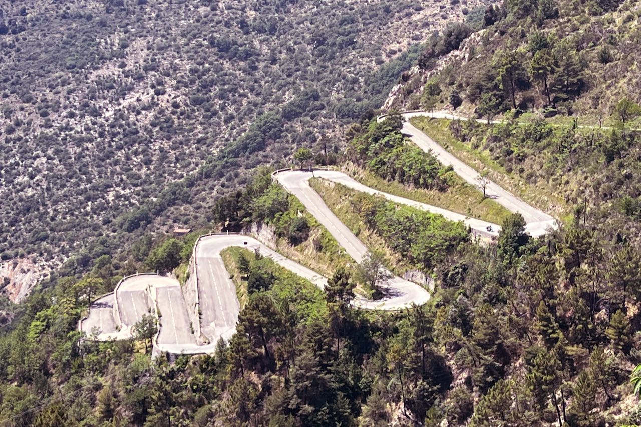
It’s incredible. It’s as if you’ve entered another world, and quickly, at that. You look up and see the road ahead of you just snaking its way all the way around and up this canyon. There are several retaining walls, some fencing holding back potential landslides, and for some reason, it all felt like it was part of some historic military road.

I found myself looking back a lot, too, as it’s always shocking to me to see how far up you climb in such a short amount of time when you’re out there. And it did not disappoint.

Eventually, you notice the church way up on the hill. At first, it feels quite far off, but you find your way to it before you know it. It’s called the Notre Dame de la Menour, and it’s 10 km from the town of Sospel.


It’s a popular spot for tourists to stop, as it sits perched between the gorge you just came up through and the nearby region of Moulinet. You can even climb up a set of stairs that traverse the spine of the ridge to visit the monastery itself.
Once passing the church, things seemed to change. The road flattened out a bit and you quickly come upon the town of Moulinet, which has a water fountain if you need it. The town seems encompassed by the road, as it wanders through town, and you almost forget that you’re still climbing up a mountain.

Beyond Moulinet, however, things do start to change. The road doubles back over itself with multiple lacets, or hairpins and you start to notice fir trees. Fir trees!


It was at this point where fatigue definitely started to set in for me. The road isn’t particularly steep, averaging a little over 5% average over the whole distance, but it’s still long. I remember at this point audibly asking myself when it would end!
Finally, you get to the top! And there’s a chalet and restaurant there waiting for you, along with a fountain across the way to fill up your bottles in preparation for the trip back.


Make sure to stop at the sign and say hello to my sticker!

There’s actually more to this climb, believe it or not! There’s a roundabout loop that can be done, up a small road beyond the chalet. At the top, listed on Google Maps as La Redoute, there is a stone building called the Pointe des Trois Communes…and I think an American tank!
I don’t fully know why or the story behind all this, but this pass was an important pass that was used during the World Wars. Maybe I’ll have to go back sometime to check it out!
Well, I’d be remiss if I didn’t mention the first part of the climb being my favorite. I remember posting about this day on my Instagram and putting the Jurassic Park theme song to it, because that’s just what it looked like to me at the time.
The road was definitely quite long, but I personally loved seeing where I was going and, in this particular case, seeing the church at the top of the ridge to know exactly where I was heading. It’s fun to have a market in a place like this, as it really gives you a sense of scale of what you’re doing and where you are. Looking back on the road below once you’ve climbed up is also spectacular, too, as you see the cars making their way up and around to meet you in some kind of dance with nature.
While I did enjoy the final section after Moulinet through the fir trees on the way to the top, I remember being quite fatigued, which encouraged me to continue onward with too much additional stopping. After as much climbing as I had done, I had to start being mindful of how much light I had left in the day, as there was still quite a distance to get back to my AirBnB.
The road was still incredibly beautiful through here, though, with a few stone tunnels, and the stone barriers that separate you from the canyon below. It’s a similar aesthetic that you see in a lot of other places in the hills above the French Riviera.
Given that the town of Sospel isn’t far from the base and that there is both water in Moulinet and at the top, I liked how accessible this climb was, all things considered. It’s quite manageable if you’re into this kind of riding.
And then there was this descent. Oh wow, what a descent it was, too! If you’re going back to Nice from here, you have a full blown 50 km descent ahead of you. And it’s glorious.


You find more lacets through here, and descending them is really something spectacular. I’m not even sure they have a name. But they’re so tight and the views are just endless. At some point through here I ran across a woman who was also out riding that day. For all I know, she could be on a professional team, just enjoying her local training grounds!

Just beyond here, I remember feeling quite triumphant coming through the hilltop-perched town of L’Escarène and was greeted by a couple walking by who applauded me as I rode past them. I’m going to assume that they were proud of me for doing Turini!
If you follow the route that I took beyond L’Escarène, you’ll find that there’s a bit more climbing that you can do. Just a small amount, I promise, but it’ll be worth it! It was actually one of the highlights of my entire trip when I look back on things.


I basically found a way to connect the area of L’Escarène to Sainte-Agnes on my way back to Roquebrune-Cap-Martin, which included several paved farm roads. These were roads that passed through people’s backyards, their goats, and had insane views out over canyons of the Peille area.


And, as it would turn out, taking this route dumps you out over one of the single most beautiful portions of the mountains above Menton, also known as Sainte Agnès. It’s a hidden gem, much like Peille is, and is absolutely worth the trip.
As it turns out, this section of beautiful tarmac is along part of what is called the Col de la Madone, a famous training climb ridden by Hincapie and Armstrong. I managed to ride it two days later on this same trip!
What a day this was! I highly recommend this one if you have the legs and the fitness for it.
Perhaps a rest day in order, what about heading to Italy next?