16
May
9 Minute Read
Growing up in Southern California, especially with a father who absolutely adores Yosemite, I found myself up in Yosemite several times. Once or twice for camping, another couple times for some backcountry multi-day backpacking.
The idea of riding up there, however, was a new concept for me. I’ve only been riding since 2013 or so, and given that it’s been many years since I’ve been to Yosemite, this was a peculiar opportunity.
As you’ll likely find on many other sites, there’s a secret “best time to visit” that is slowly becoming more and more common knowledge. There’s a certain time each year, usually at the end of April or the beginning of May, where the road up to Glacier Point is closed off to cars due to recent snow plowing, while still being open to bikes.
I know, right? This is why we spontaneously found a room at the Yosemite Lodge, took a day or two off of work, grabbed the bikes, and drove on up. Luckily from the Bay Area, Yosemite only takes about 4 hours to get to.
For 2021, after May 21st, Yosemite requires you to have a separate reservation pass just to get into the park. This is above and beyond any reservations you may have, so keep that in mind! I think this has been going on for a few years now, as managing the amount of tourists into the valley has become more and more difficult.
There are a couple ways to do this, but this is what we settled on:
To sum up, the most common ways people do this ride:
If you stay in the valley, you can cut off a lot of distance for the ride in total, as you’re going to want to bike through the valley regardless. If you end up staying near Wawona, south of the cutoff over to Glacier Point, you’re going to end up making a much longer day out of this ride, usually around 90 miles (!) or more. That particular route also includes quite a long climb up and over into Wawona itself.
While it’s beautiful over in Wawona, it’s going to pale in comparison to Yosemite Valley and Glacier Point. It is the home of the very cool historic Wawona Hotel, which has almost a Southern plantation style going for it.
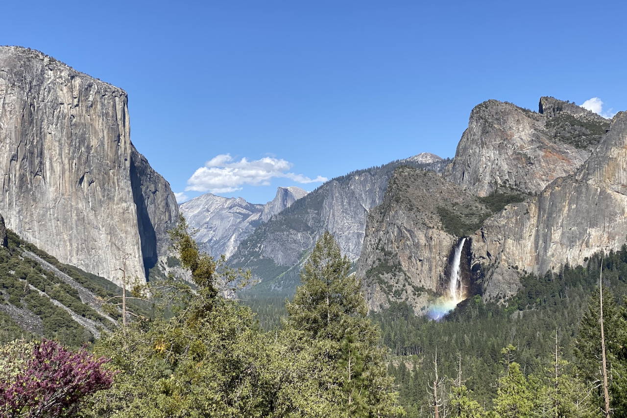
If you can manage to secure a room over at the Yosemite Lodge, you’ll be able to walk out to the parking lot and see the world-famous Yosemite Falls.

The valley itself is around 4,000 feet above sea level, and is quite flat. It has wonderful pavement, and the majority of the route through it is a two lane road that is one-way traffic only. This means that you can meander through a bit without the worry of taking up too much of the road while you’re sightseeing in one of the most spectacular places on Earth.

Seriously, you’re going to be stopping every few hundred yards. Don’t forget to pay attention to the road, but take your time through here!
Following the route, you’ll head up a bit and end up at Tunnel View, the single most famous viewpoint overlooking the valley. You’ll definitely want to stop here, along with everyone else! If you’re following the route from the valley, you’ll end up coming back through here later in the day, so you’ll get a second chance to see this view point.

Once you’re ready to head out, make sure you have good rear lights on, check that the coast is clear, and start heading up into it. It’s slightly uphill, so while not difficult, you definitely won’t be traveling at the same speed as the cars passing you.

While I personally didn’t find it too harrowing or nerve-wracking, my girlfriend was a bit anxious in there, so we made sure to get through it quickly. It’s about a mile long, and it’s quite loud inside!
There’s another great view out over the valley just past the tunnel, so don’t forget to look back over your shoulder to see it!
The next few miles are where the elevation may start to hit you, depending on how well adjusted you are to it. In our case, we had only driven up the previous day, so we did not have too much time to adjust. So while the overall elevation wasn’t as high as it was when we did Mount Lemmon in Tucson, we had to take similar precautions.
There isn’t a lot of shoulder along this section, and it isn’t even the section that would be shut down anyway during the magical “bikes only” week, so be careful, be visible, and be predictable. There’s a large area that was previously burned a few years ago, which does actually help aid your visibility. It also rewards you with vertigo-inducing views of the valley beyond Yosemite Valley, which is quite spectacular.
At the roundabout, you head up another 16 miles or so to the very end. Given the altitude, it’s going to take likely around two hours, depending on how much you stop for breaks, snacks, and your pace. It’s beautiful, but the right bends in the road can be a bit nerve wracking, as you’re the small bicyclist hugging the right side of the road to the point where cars don’t always see you clearly until they’re close around the bend. Luckily, the speed limit isn’t too high through most of that road!

Overall, it wasn’t too bad. What helped settle my mind a lot though was having a Garmin Varia Radar, which was the best impulse buy I’ve ever made in my cycling career.
Make sure to stop here! It is perhaps the most incredible view you’re going to see up this way.

According to my father, the views out from Washburn Point are even better than they are from Glacier Point itself. I’m inclined to agree!
For those not as familiar, Half Dome is one of the main attractions of Yosemite Valley, standing as one of the highest viewable points from the valley floor at 8,839 feet above sea level. It, along with El Capitan, are sometimes referred to as the “guardians” of the valley, if memory serves me correctly.
Everyone was so friendly when we stopped here, by the way. They were all amazed at how we had managed to make it all the way up there on our bikes from the valley down below! I think we were just glad that we had made it up to that point.
The trail from the valley floor to Half Dome is incredibly steep and incredibly long, climaxing in the famous “cables” that are not for the faint of heart. It’s not easily done as a day hike, despite a lot of people thinking that they can make it one.

Seeing it from up top is a great way to get a sense for where you may have already been or plan to go.
I’ve done it twice in my lifetime, both years ago, and both at the end of a several day excursion that started in the backcountry. This means I’ve only ever gone down the full trail and never up it from the valley floor.
The two waterfalls are first Vernal Fall and second Nevada Fall. Vernal is closer to the valley floor and is known for producing a lot of mist and rainbow-like views near the trail to it. Nevada is further up from the valley, is much larger in size, and has a fun sign near the top that tells you not to swim up there by saying “if you slip and go over the falls, you will die”. At least it used to, as I remember seeing it when I was younger. And you don’t want to swim in the Emerald Pool.
The NPS (National Park Service) also has a good page about the hike in general here.
From Washburn Point, you actually descend a bit. But then you come to this famous turn in the road that makes you feel almost like you could ride straight off the side of a cliff. It truly takes your breath away when you’re out there on your bike, after having made it all the way up there on your own power!

These last few switchbacks are cycling nirvana, too. It definitely reminded me of some of the epic riding I’ve done in the past out in the Alps!

Ah, finally! At the bottom of this small-ish descent is the main attraction, the destination you’ve been riding to see. Walk out past the parking lot (it doubles back around), use the restrooms, and if the little store is open, grab a sandwich and something to drink and go hang out for a bit. It’s wonderful.

Although you gotta watch out for those squirrels. They’re an aggressive bunch.

This part was awesome. There’s definitely some ascending that still has to be done going back down into the valley, but they’re largely short by comparison to what you’ve already done.
It was just so much fun. And it’s a long one! It’s amazing to see how quickly you’re back in the valley compared to how long it took to get up there.
Definitely make sure to stop again at Tunnel View once you’re there. It’s magical at all times of the day!

If you’re like us and heading back into the valley to call it a day, make sure to wander around the loop a bit. Chances are you’ve already driven part of it, but it definitely feels so much bigger on a bike.
Check out Curry Village and even the “old town” of Yosemite Village, where there’s a post office, a graveyard (where some of the original settlers of the valley are buried), some houses, the Village Store, and a grab and go pizza spot called Degnan’s. Alternatively, check out the Base Camp Eatery or grab a drink once you’re done at The Mountain Room Lounge.
Absolutely. Positively. One-hundred-and-fifty-thousand-percent.


