14
Dec
9 Minute Read
What better way to start off a new section to my site than with Old La Honda?
As far as Bay Area riding, it really doesn’t get any better than this. Honestly.
Where I grew up, in Southern California, roads like this didn’t exist. Not that this road is something out of the Monaco circuit in terms of quality of tarmac. Not by any stretch of the imagination.
But these trees, the forest, the views through those trees, the way the light filters through them. It’s wonderful. It epitomizes what I like most about riding my bike in the Bay Area.
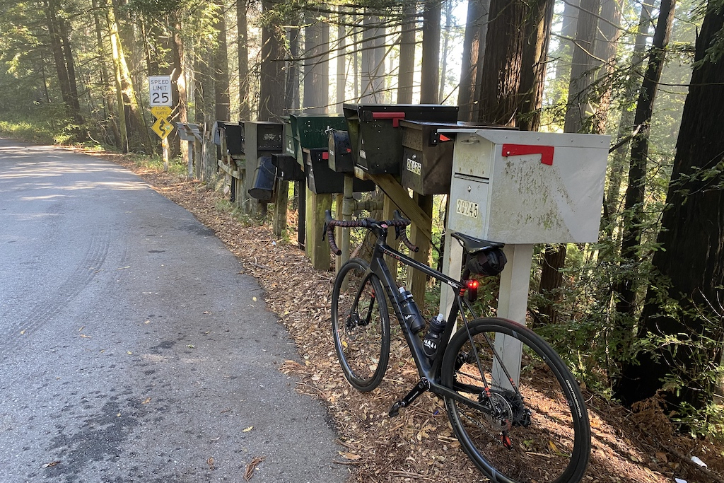
Because of course! The “official” segment, which isn’t really official at all of course, is here. The “bridge to mailboxes”. You actually have to look a bit to notice the bridge (at least I did).
The climb is about 3 miles, with a total elevation change of about 1290 feet, depending on how you measure it. A cursory Google search online will show that there are a lot of information and websites about this particular stretch of road. Which is funny to me, because it’s so quiet and, frankly, out of the way for nearly everyone except cyclists and those who live along the road.
It’s a wonderful climb, pretty gradual, but the more you do it and get familiar with it, the more you realize that it has its “pitchy” moments. I don’t think I noticed it nearly so much the first few times I rode up it. I also felt like it was quite long at first, given that climbing in Southern California is basically super short (albeit steep at times) or crazy-epic-long like Mt. Wilson or Baldy near Los Angeles.
There’s an area just off of Portola Road (which is Sand Hill road when it meanders over into Palo Alto) that all the cyclists typically stop to regroup. It’s right at a gated driveway to a private road where there are a few houses.

Sometimes, there are horses that are anxiously waiting to see you off, too.

By the way, this is private property through here, so please be considerate. I once witnessed someone off in the bushes relieving himself and a frustrated man who lived right along here sure made his frustration known as he drove past us. Definitely shouldn’t be doing anything to give us cyclists a bad name!
So while the time up this climb can be all over the place, it’s usually about a 30 minute climb, nearing closer to 20 (or under!) if you’re a really fit or strong cyclist. Phil Gaimon actually currently holds the KOM for this segment at some insane time of 13 minutes, so don’t use that as your comparison!
This caught me the first time I went up, as I saw the first set of mailboxes about halfway up and thought I was near the top. I ended up getting significantly more tired on that back half!

There are three major pitches that I look for while going up this road, each of which are the inside apex of a right hand turn. Often, I see others (and myself) standing out of the saddle to get over these steeper pitches, which is fine if you’re strong. However, my best times up this road did not actually include me doing this, as the extra exertion I push through in slowing my cadence and position actually tired me out unnecessarily without also gaining me much speed. To each their own!
While there aren’t many cars on this road, there definitely still are cars. Please take care to not cut corners too sharply without adequate visibility. There could be a downhill cyclist coming the other way, too! It’s very easy to become distracted out here, as the road bends back around itself sometimes, making for beautiful views out over sections of road you just came up.
While I certainly don’t feel super qualified to give out much advice on this one (I’m still trying to break that 20 minute barrier!), I’ve found it useful to break the road up into thirds.
Initially, it’s somewhat steep, especially just coming out of the first ravine, which is called Thornewood Preserve. You’ll usually see cars parked here on the outside of a sweeping left hand turn, as there is a trailhead here. It can get muddy in the winter months, but I’ve personally never been out there.

Just after Thornewood, you’ll climb up to see your first left-hand viewpoint over the valley. It’s probably the most sweeping view that you’ll see while going up this road, as it does tend to bury itself under the cover of the trees the further up you go. Or is it because I’m usually too tired by the time I go up further? There are definitely other views further up this climb, but they’re usually only really noticeable during the winter months when the trees are a bit more bare.

It levels out a bit here into a gradual climb through some long driveways. Get settled in, enjoy the views, and pace yourself.
So the dividing line here is a bit unclear, but I personally feel like the second third begins at a somewhat-recently-placed mirror on a telephone pole, which is followed by one of those steep right handers where you have to go up the inner apex of the turn.

A little bit further up is where I tend to subdivide things further (hey, I am an engineer after all) into the halfway point. I recognize it visually by this house right off to the right of the road. It comes up just prior to the road diving back into the woods a bit more.

I just love how the road winds around itself up here. It even passes by a fancy house you can look down into a bit as well as another horse ranch.
As contrast though, there are a few sections through here where the gradient actually levels off a bit, which can be really deceiving if you’re going for a good time on the climb. It’s really easy to sit back and lull yourself into a sense of recovery, when you’re actually likely to lose more time through here than you may think!
Overall, this part is one of my more favorite sections, though, as it becomes a bit denser and more green. I particularly like this section where a small cluster of trees appear to hug the road, making for a very small, natural entryway. Kind of reminds me of those tight sections of road you’ll find up in Redwood forests.

So this one occurs just after the last of the three steep right handed turns mentioned earlier, which often fills you with hope and (sometimes) a renewed sense of energy. Which is good, of course, because the last part of the previous section is where attrition definitely begins to set in for me.

Good to know that someone up there has a sense of humor!
The road opens up a bit, but recedes back under cover pretty quickly, and the road gets a bit windy again, with some steeper initial pitches that eventually level out. But perhaps that’s just the fatigue setting in! You’ll know you’re starting to get towards the final few bends when you see a small house on the left side of the road.

At this point, the last several turns all look extremely similar to each other. I’ve heard other cyclists voice this as well, so I know it’s not just me! Here’s a simple way to know what’s coming up!
When you see a wooden gate to a dirt path up the side of the hill on the right side of the road, you can begin counting down from three.

The road will bend left, then go right into another, similar looking ravine. Look for a large tree covered with smaller leaves that kind of look like moss. Around the bend a bit further, you’ll see a lot more of it covering the side of the hill. Count down to two, check!

Finally, you’ll come around another bend, which is the final main bend before the road is complete up at the mailboxes at Skyline blvd! Look for a small, but still prominent reflector on the right side of the road. Count to one and get ready to charge that final hill!

You made it! It’s amazing how different this place looks at different times of day and year.
In the morning, the sun comes in from the southeast, from the valley side:

In the evening, it’s reversed, but comes in much more orange and yellow, with longer rays:

Karl even decides to show his face quite often, as the ridge that Skyline road runs down the spine of is known for this kind of weather:

Wait here for a few minutes at nearly any time of day and you’ll likely be joined by at least one other cyclist coming through this area. It almost feels like a social gathering, and I’ve started several conversations up here with random people and even run into friends. I’ve even seen sheep up here!

So you could just got right back down, but where’s the fun in that?
By far the most popular way to go down is to actually go up just a little bit further, up north along Skyline for about a mile and a half. This puts you at a junction with Alice’s Restaurant, an old school biker-like bar where there are often a lot of fancy cars parked out with their friends.

If you go across the way (the east side of Skyline), there’s a water spout that can be used to fill up your bottles, too.
Take the 84 highway down (I don’t really advise going up this direction, though) and you’ll find yourself at the center of Woodside, very near to where you started!
There are so many other options of where to go from the top of Old La Honda, which is another reason why I like it so much. It can represent adventure. But it can also represent training. Or just simply beauty.
Whatever it is for you, “it’s always a good time up on Skyline.” That’s what I like to say, anyway!


